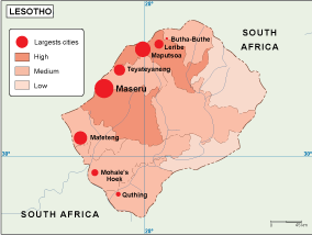
Description
Lesotho Population Map – Premium Editable Vector Map
The lesotho population map vector map is part of the Netmaps professional cartographic database, designed for high-precision work in design, publishing and business environments. It provides a structured and detailed representation of the territory, making it suitable for advanced visual communication.
Delivered in Adobe Illustrator (AI) and EPS formats, this map is fully editable. Users can modify layers, colours, typography and geographic elements without limitation. The map includes including major districts, transport networks and surrounding areas, ensuring a professional level of detail.
Geographic Detail and Structure
The map highlights important geographic patterns and territorial structure. This makes the map highly effective for projects where geographic accuracy and clarity are essential.
The structure of the map allows easy adaptation to different visual styles and formats, from print publications to digital presentations.
Professional Applications
This vector map is widely used in corporate communication, marketing and data visualisation. It enables seamless integration into professional workflows and allows complete customisation for specific needs.
Unlike static images, vector maps provide flexibility and scalability, making them ideal for evolving projects.
Delivery and Usage Rights
After purchase, the file is delivered via WeTransfer and email for immediate access. The product includes professional and commercial usage rights.
All maps belong to the Netmaps vector database, used globally by designers, companies and institutions.
In summary, the lesotho population map vector map is a professional-grade solution for precise and flexible geographic representation.